Columbiaville, New York - Columbiaville, New York
Columbiaville, New York | |
|---|---|
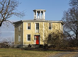
 The Octagon House of Columbiaville
| |
| Koordinater: 42 ° 19′06 ″ N 73 ° 45′11 ″ W / 42,31833 ° N 73,75306 ° W Koordinater : 42 ° 19′06 ″ N 73 ° 45′11 ″ W / 42,31833 ° N 73,75306 ° W | |
| Land | forente stater |
| Stat | New York |
| fylke | Columbia |
| Elevation | 43 m |
| Tidssone | UTC-5 ( østlig (EST) ) |
| • Sommer ( DST ) | UTC-4 (EDT) |
| post kode | 12050 |
| Retningsnummer (er) | 518 & 838 |
| GNIS- funksjons-ID | 947196 |
Columbiaville er en grend i byen Stockport , Columbia County , New York , USA. Samfunnet ligger langs US Route 9 7,9 km nord-nordøst for Hudson . Columbiaville har et postkontor med postnummer 12050, som åpnet 28. desember 1888.
referanser
![]() Media relatert til Columbiaville, New York på Wikimedia Commons
Media relatert til Columbiaville, New York på Wikimedia Commons
| Denne artikkelen om et sted i Columbia County, New York, er en stubbe . Du kan hjelpe Wikipedia ved å utvide den . |


