Indiana State Road 134 - Indiana State Road 134
| State Road 134 | ||||
|---|---|---|---|---|
| Jenter skolevei | ||||
 | ||||
| Ruteinformasjon | ||||
| Vedlikeholdt av INDOT | ||||
| Lengde | 0,379 km | |||
| Store kryss | ||||
| Sørenden | Girls School Road i Indianapolis | |||
| Nordenden |
|
|||
| plassering | ||||
| fylker | Marion | |||
| Motorvei system | ||||
| ||||
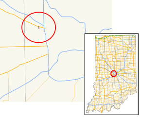
State Road 134 er en veldig kort nord – sør statsvei i Marion County .
Rutebeskrivelse
State Road 134 begynner ved Indiana Women's Prison og kjører direkte nordover til US Route 136 (Crawfordsville Road), en avstand på 0,60 miles (0,60 miles).
Historie
SR 134 ble lagt til det statlige veisystemet mellom slutten av 1930 og 1931, på samme rute som det for tiden tar, i løpet av det første året ble veien behandlet med olje. Veien hele SR 134 ble asfaltert i 1932. Siden begynnelsen av 1930-årene har ikke mye endret seg med SR 134.
Store kryss
Hele ruten er i Indianapolis , Marion County .
| mi | km | destinasjoner | Merknader | ||
|---|---|---|---|---|---|
| 0.000 | 0.000 | Jenter skolevei sør | Den sørlige enden av SR 134 | ||
| 0,379 | 0,610 |
|
Nordterminal av SR 134 | ||
| 1.000 mi = 1.609 km; 1.000 km = 0.621 mi | |||||
referanser
- ^ a b Indiana Department of Transportation (juli 2015). Referansepostbok (PDF) . Indianapolis: Indiana Department of Transportation . Hentet 17. september 2016 .
- ^ Indiana State Highway Commission (1. august 1930). State Highway System of Indiana (kart). Indiana State Highway Commission . Hentet 16. mars 2018 - via Indiana State Library and Historical Bureau.
- ^ Indiana State Highway Commission (1. januar 1932). State Highway System of Indiana (kart). 1: 660000. Indianapolis: Indiana State Highway Commission. OCLC 53092152 . Hentet 16. mars 2018 - via Indiana State Library and Historical Bureau.
-
^ "Oiling Goes On; The State Roads" . The Daily Reporter . 11. juli 1931 . Hentet 16. mars 2018 - via Newspapers.com .

- ^ Indiana State Highway Commission (30. september 1930). State Highway System of Indiana (PDF) (Kart). Indianapolis: Indiana State Highway Commission . Hentet 16. mars 2018 - via Indiana University Bloomington Libraries.
- ^ a b Indiana State Highway Commission (februar 1933). State Highway System of Indiana (kart). 1: 618000. Indiana State Highway Commission. OCLC 53355434 . Hentet 16. mars 2018 - via Indiana State Library and Historical Bureau.
- ^ Indiana Department of Transportation (2018). Indiana Roadway Map 2018 (PDF) (Map). 1: 550.000. Indianapolis: Indiana Department of Transportation . Hentet 16. mars 2018 .
Eksterne linker
Rutekart :
|
KML-fil ( rediger • hjelp )
|

