| Rang
|
Navn
|
Bilde
|
Høyde
fot (m)
|
Gulv
|
År
|
plassering
|
Bruk
|
Merknader
|
|
01.01
|
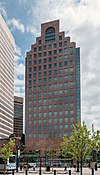
Industrial National Bank Building
|

|
428 (130)
|
26
|
1928
|
Providence
41 ° 49′28,27 ″ N 71 ° 24′39,89 ″ V / 41.8245194 ° N 71.4110806 ° W / 41.8245194; -71.4110806 ( : Industrial National Bank Building )
|
Ledig
|
|
|
02.02
|
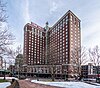
Én Financial Plaza
|

|
410 (125)
|
30
|
1973
|
Providence
41 ° 49′31.11 ″ N 71 ° 24′36.14 ″ V / 41.8253083 ° N 71.4100389 ° W / 41.8253083; -71.4100389 ( One Financial Plaza )
|
Kontor
|
- Bygget som Hospital Trust Tower
- Også kjent som Sovereign Bank Tower
|
|
03.03
|
The Residences Providence
|

|
380 (116)
|
31
|
2007
|
Providence
41 ° 49′30.32 ″ N 71 ° 24′54.77 ″ V / 41.8250889 ° N 71.4152139 ° W / 41.8250889; -71.4152139 ( The Residences at the Westin )
|
Bolig
|
|
|
04.04
|
Omni Providence Hotel
|

|
329 (100)
|
25
|
1993
|
Providence
41 ° 49′31.15 ″ N 71 ° 24′58.5 ″ W / 41.8253194 ° N 71.416250 ° W / 41.8253194; -71.416250 ( The Westin Providence )
|
Hotell
|
- Tidligere Westin Providence
- Ble det høyeste hotellet i Providence etter ferdigstillelsen, og overgikk Providence Biltmore
|
| Ikke tilgjengelig
|
Manchester Street Generating Station
|

|
321 (98)
|
|
1996
|
Providence
41 ° 48′57 ″ N 71 ° 24′16 ″ V / 41.815829 ° N 71.404329 ° W / 41.815829; -71.404329 ( Manchester Street Generating Station )
|
Kraftstasjon
|
- Røykstakkene på Manchester Street Generating Station stiger til en høyde på 321 fot
|
|
05.05
|
Textron Tower
|

|
311 (95)
|
23
|
1971-72
|
Providence
41 ° 49′29,63 ″ N 71 ° 24′33,05 ″ V / 41.8248972 ° N 71.4091806 ° W / 41.8248972; -71.4091806 ( Textron Tower )
|
Kontor
|
- Bygget som Old Stone Tower
|
|
06.06
|
50 Kennedy Plaza
|
|
285 (87)
|
20
|
1985
|
Providence
41 ° 49′29,8 ″ N 71 ° 24′38,09 ″ W / 41,824944 ° N 71,4105806 ° W / 41.824944; -71.4105806 ( 50 Kennedy Plaza )
|
Kontor
|
|
|
07.07
|
Blue Cross & Blue Shield of Rhode Island Headquarters
|

|
236 (72)
|
14
|
2009
|
Providence
41 ° 49′40.2672 ″ N 71 ° 24′48.261 ″ W / 41.827852000 ° N 71.41340583 ° W / 41.827852000; -71.41340583 ( Blue Cross & Blue Shield of Rhode Island Headquarters )
|
Kontor
|
|
|
08.08
|
Vannplass 1
|

|
236 (72)
|
19
|
2008
|
Providence
41 ° 49′38,44 ″ N 71 ° 24′45,098 ″ V / 41.8273444 ° N 71.41252722 ° W / 41.8273444; -71.41252722 ( Vannplass 1 )
|
Bolig
|
|
|
09.09
|
Rhode Island State House
|
|
223 (68)
|
4
|
1904
|
Providence
41 ° 49′51.1032 ″ N 71 ° 24′54.053 ″ V / 41.830862000 ° N 71.41501472 ° W / 41.830862000; -71.41501472 ( Rhode Island State House )
|
Statlige
|
|
| 10 =
|
Biltmore Hotel
|
|
220 (67)
|
18
|
1922
|
Providence
41 ° 49′27,73 ″ N 71 ° 24′48,4 ″ W / 41,8243694 ° N 71,413444 ° W / 41.8243694; -71.413444 ( Biltmore Hotel )
|
Hotell
|
- Byens høyeste hotell fra 1922 til ferdigstillelsen av Westin Providence i 1993
|
| 10 =
|
Tårnet i Carnegie Abbey
|
|
220 (67)
|
17
|
2009
|
Portsmouth
41 ° 36′58,3 ″ N 71 ° 16′10,8 ″ V / 41.616194 ° N 71.269667 ° W / 41.616194; -71.269667
|
Bolig
|
|
| 12
|
Providence County tinghus
|

|
217 (66)
|
7
|
1930
|
Providence
41 ° 49′31.76 ″ N 71 ° 24′24.84 ″ W / 41.8254889 ° N 71.4069000 ° W / 41.8254889; -71.4069000 ( Providence County tinghus )
|
Statlige
|
|
| 1. 3
|
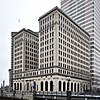
Turks hodebygning
|

|
217 (66)
|
16
|
1913
|
Providence
41 ° 49′28,42 ″ N 71 ° 24′35,5 ″ W / 41.8245611 ° N 71.409861 ° W / 41.8245611; -71.409861 ( Turks hovedbygning )
|
Kontor
|
|
| 14
|
Vannplass 2
|

|
210 (64)
|
17
|
2008
|
Providence
41 ° 49′38,22 ″ N 71 ° 24′48,05 ″ V / 41.8272833 ° N 71.4133472 ° W / 41.8272833; -71.4133472 ( Waterplace 2 )
|
Bolig
|
|
| 15
|
Pawtucket rådhus
|

|
209 (64)
|
3
|
1933
|
Pawtucket
41 ° 52′44,2 ″ N 71 ° 22′55,8 ″ W / 41.878944 ° N 71.382167 ° W / 41.878944; -71.382167
|
Statlige
|
- Høyeste bygning i Pawtucket
|
| 16
|
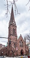
Grace kirke
|
|
~ 206 (63)
|
1
|
1860
|
Providence
41 ° 49′19 ″ N 71 ° 24′49 ″ V / 41.82183 ° N 71.413507 ° W / 41.82183; -71.413507 ( Grace Church )
|
Kirke
|
| 17 =
|
Carrol Tower
|

|
199 (61)
|
16
|
1973
|
Providence
41 ° 49′38,22 ″ N 71 ° 24′48,05 ″ V / 41.8272833 ° N 71.4133472 ° W / 41.8272833; -71.4133472 ( Waterplace 2 )
|
Bolig
|
- Twin tower of Parenti Villa
|
| 17 =
|
Parenti Villa
|

|
199 (61)
|
16
|
1973
|
Providence
41 ° 49′11,6 ″ N 71 ° 26′10,0 ″ W / 41,819889 ° N 71,436111 ° W / 41.819889; -71.436111 ( Waterplace 2 )
|
Bolig
|
- Dobbelt tårn i Carrol Tower.
|
| 19
|
Towers East
|
|
194 (59)
|
16
|
1976
|
Pawtucket
41 ° 52′33 ″ N 71 ° 23′09 ″ V / 41.875806 ° N 71.385755 ° W / 41.875806; -71.385755 ( Slater Hill )
|
Bolig
|
|
| 20
|
Første Unitarian Church of Providence
|

|
189 (58)
|
|
1816
|
Providence
41 ° 49′28 ″ N 71 ° 24′18 ″ W / 41,824381 ° N 71,404901 ° W / 41.824381; -71.404901 ( First Unitarian Church )
|
Kirke
|
|
| 21
|
Charlesgate North
|
|
187 (57)
|
15
|
1970
|
Providence
41 ° 50′19.6902 ″ N 71 ° 24′35.2368 ″ V / 41.838802833 ° N 71.409788000 ° W / 41.838802833; -71.409788000 ( Waterplace 2 )
|
Bolig
|
|
| 22
|
Første baptistkirke
|
|
185 (56)
|
|
1775
|
Providence
41 ° 49′39 ″ N 71 ° 24′30 ″ V / 41.827476 ° N 71.408292 ° W / 41.827476; -71.408292 ( First Baptist Church )
|
Kirke
|
|
| 23
|
Fogarty Manor
|
|
182 (55)
|
|
1969
|
Pawtucket
41 ° 52′50 ″ N 71 ° 22′59 ″ V / 41.880481 ° N 71.38316 ° W / 41.880481; -71.38316 ( Slater Hill )
|
Bolig
|
|
| 24 =
|
One Citizens Plaza
|

|
180 (55)
|
1. 3
|
1990
|
Providence
41 ° 49′38.4558 ″ N 71 ° 24′38.2926 ″ V / 41.827348833 ° N 71.410636833 ° W / 41.827348833; -71.410636833 ( One Citizens Plaza )
|
Kontor
|
|
| 24 =
|
Brown University Sciences Library
|

|
180 (55)
|
15
|
1971
|
Providence
41 ° 49′36,85 ″ N 71 ° 24′0,49 ″ V / 41.8269028 ° N 71.4001361 ° W / 41.8269028; -71.4001361 ( Brown University Sciences Library )
|
universitet
|
- Med sin tidligere antennemast inkludert, nådde bygningen en total høyde på 395 fot (120 m), mer enn doblet den effektive høyden og gjorde den til den tredje høyeste bygningen i byen når den ble målt etter topphøyde.
|
| 26
|
121 South Main Street
|

|
178 (54)
|
11
|
1984
|
Providence
41 ° 49′27 ″ N 71 ° 24′25 ″ W / 41.824074 ° N 71.407019 ° W / 41.824074; -71.407019 ( 121 South Main Street )
|
universitet
|
|
| 27
|
Hospital Trust Building
|
|
177 (54)
|
1. 3
|
1920
|
Providence
41 ° 49′32,38 ″ N 71 ° 24′34,83 ″ V / 41.8256611 ° N 71.4096750 ° W / 41.8256611; -71.4096750 ( Hospital Trust Building )
|
universitet
|
- Også kjent som Fleet Building
- Eies for tiden av Rhode Island School of Design og brukes som et bolighus
|
| 28
|
Søster Dominica Manor
|

|
175 (53)
|
16
|
1966
|
Providence
41 ° 49′21,84 ″ N 71 ° 25′16,69 ″ V / 41.8227333 ° N 71.4213028 ° W / 41.8227333; -71.4213028 ( Søster Dominica Manor )
|
Bolig
|
- Bygget som Bradford House
|
| 29
|
Hilton Providence Hotel
|

|
~ 173 (53)
|
14
|
1969
|
Providence
41 ° 49′23 ″ N 71 ° 25′07 ″ V / 41.822989 ° N 71.418550 ° W / 41.822989; -71.418550 ( Hilton Providence )
|
Hotell
|
|
| 30
|
Edge College Hill
|
|
172 (52)
|
15
|
2018
|
Providence
41 ° 49′40 ″ N 71 ° 24′36 ″ W / 41.827908 ° N 71.410074 ° W / 41.827908; -71.410074 ( Edge College Hill )
|
Bolig
|
|
| 31
|
Slater Hill Apartments
|
|
170 (52)
|
14
|
|
Pawtucket
41 ° 52′29 ″ N 71 ° 23′10 ″ W / 41.874726 ° N 71.386038 ° W / 41.874726; -71.386038 ( Slater Hill )
|
Bolig
|
|
| 32
|
One Regency Plaza
|
|
~ 161
|
1. 3
|
1973
|
|
Bolig
|
|
| 33
|
Bannigan Building
|

|
~ 160 (49)
|
11
|
1896
|
Providence
41 ° 49′29 ″ N 71 ° 24′33 ″ W / 41,824679 ° N 71,409209 ° W / 41.824679; -71.409209 ( Bannigan Building )
|
Kontor
|
|
| 34
|
Union Trust Company Building
|

|
~ 157 (48)
|
12
|
1902
|
Providence
41 ° 49′25 ″ N 71 ° 24′41 ″ W / 41,823685 ° N 71,411350 ° W / 41.823685; -71.411350 ( Union Trust Company Building )
|
Kontor
|
|
| 35
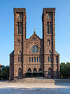
|
De hellige Peter og Pauls katedral
|
|
156 (48)
|
|
1889
|
Providence
41 ° 49′09, N 71 ° 24′59, W / 41,819282 ° N 71,416506 ° W / 41.819282; -71.416506 ( Union Trust Company Building )
|
Kirke
|
|


.jpg)

.jpg)


.jpg)
.jpg)


